
E. Request to Address Council
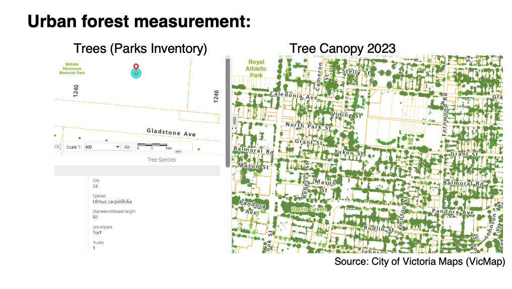
Slide 1 – The City of Victoria has collected urban tree canopy data over multiple years by to perform ongoing measurements of its urban forest canopy. The City has outsourced urban tree canopy monitoring (i.e., vegetation) twice the past, measuring between 2007-2013 and 2013-2019. This process should be repeated with the recently obtained urban tree canopy measurement capture in LiDAR for 2023. By doing so, there will be better understanding of how the urban forest has been impacted by development policies and practices between 2019 and 2023.
The results of urban forest monitoring compares urban forest measurements over time and clarifies how present land use development policies and the Tree Protection Bylaw interrelate. This analysis is integral to understanding proposed changes to the Official Community Plan (OCP) and the potential for neighbourhood level urban tree canopy loss over the medium to long term.
Research supports how deficiencies in tree canopy at the neighborhood-level
a) diminish residents’ physical and mental health outcomes;
b) removes wildlife habitat and reduce overall species diversity; and
c) reduces ecosystem services capacity, for example, provision of surface shading during heatwaves and reducing peak stormwater flows.

Slide 2 – From 2013 to 2019, Victoria’s urban forest grew by 2.37%, achieving a citywide canopy cover of 28.8%. The growth measured during this period predates the updated Tree Protection Bylaw (21-035) and adoption of required tree minimums through the development process.
The Tree Protection Bylaw has not been updated since the introduction of City of Victoria’s Missing Middle Housing Initiative and the Province of BC Bills 44 and 37. This is significant, because housing policies which prioritize the built environment can undermine physical protections for trees and tree minimums thru developments established in the Tree Protection Bylaw – and the families of wildlife trees support.
The targeted tree density (i.e., “tree minimum) established in the Bylaw have so far not been evaluated for effectiveness. This approach to urban forestry stewardship through urban development is theoretical. It lacks empirical evidence to support its effectiveness and continued application.
Over 75% of the urban forest is on private property. While the Tree Reserve Fund has collected nearly 1.8 million dollars from January 2021 to March 2024, The accumulation of funds in the Tree Reserve between 2021-2023 is evidence of that ineffectiveness. In only 3 years the City accumulated $1,047,000 from developments that could not achieve the tree minimum, which equals net deficit of 523 trees from private property.
The release of 2023 LiDAR data, and the City’s own Tree Protection Bylaw metrics concerning tree removal and replacement related to development presents a timely opportunity to update urban forest monitoring. Analyzing changes from 2019 to 2023 will improve City of Victoria’s understanding of existing urban forest policies and the links to land use development changes over the past five years. This will also help inform Bylaw modernization, and improve the potential for realizing the goals set forth in the “Victoria 2050” vision and in the Urban Forest Master Plan.
On behalf of the RNA LUC, I would offer the following recommendations to Mayor and Council as part of the OCP review process:
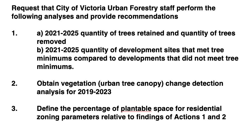
Slide 3 We request that City of Victoria Urban Forestry staff perform the following data analyses and provide recommendations to incorporate in the Draft OCP “Victoria 2025.”
- a) 2021-2025 neighbourhood-level metrics on quantity of trees retained and quantity of trees removed through developments, and b) 2021-2025 neighbourhood-level metrics on quantity of development sites that met Tree Protection Bylaw tree minimums compared to developments that did not meet the Tree Protection Bylaw tree minimums.
- Obtain vegetation (urban tree canopy) change detection analysis for 2019-2023 using the methods of previous monitoring surveys conducted by Terra Remote Sensing
- Define the percentage of plantable space for residential zoning parameters relative to findings of Actions 1 and 2
![Squirrealism: Psychometry (IIC) in artistic practice. [Online presentation] International Multispecies Methods Research Symposium, University of Saskatchewan, Saskatoon, Canada.](https://www.carollyne.com/wp-content/uploads/2023/06/Screen-Shot-2023-06-18-at-9.16.32-PM-copy-1-500x383.jpg)